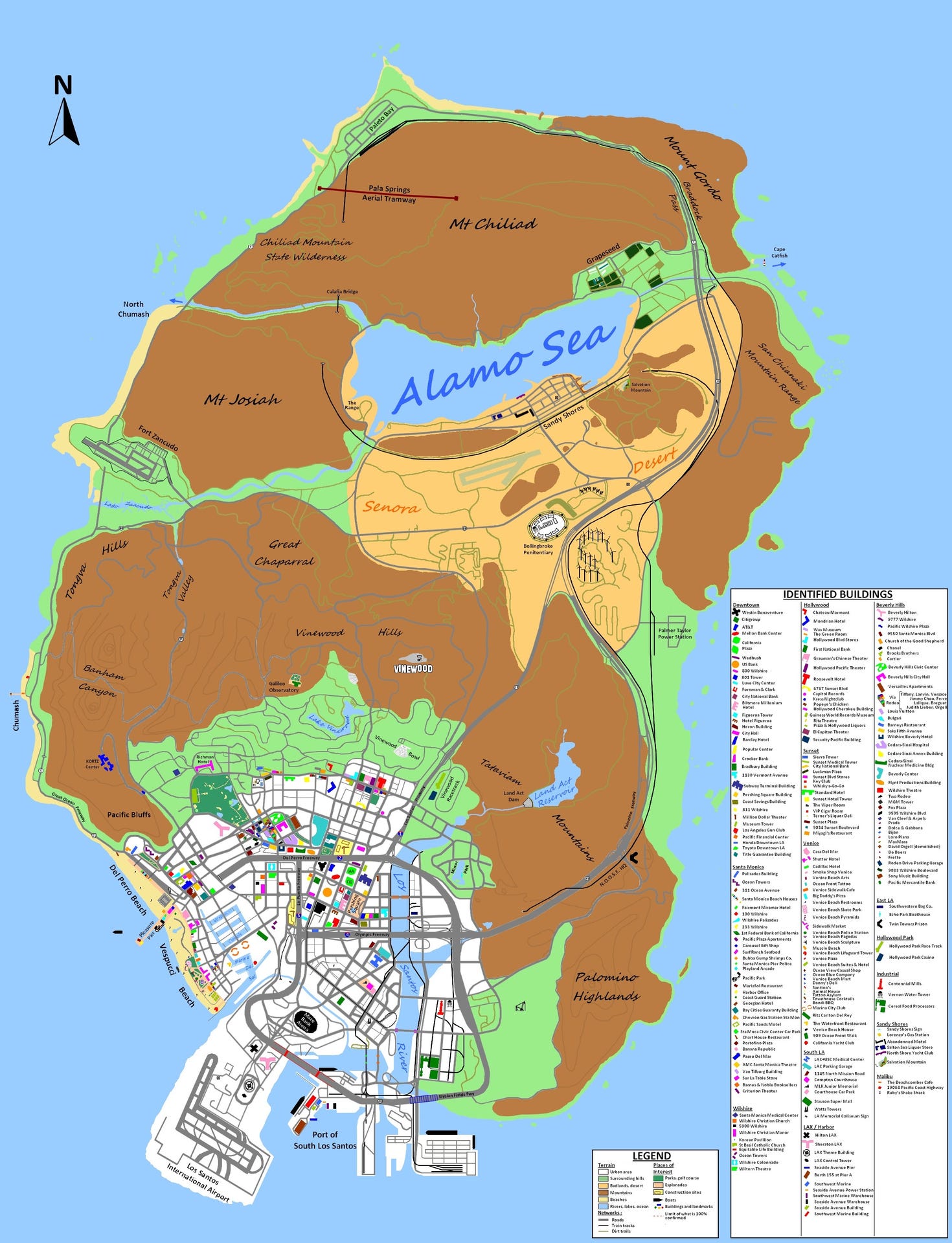
Mapping Los Santos
The story of the fans who cracked Grand Theft Auto 5's secrets, and how they did it.

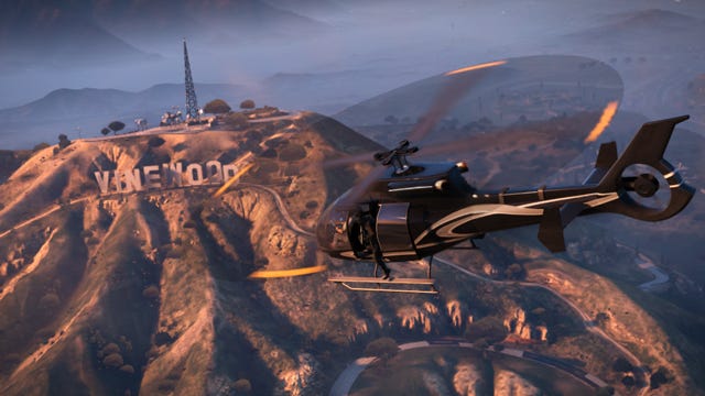
In July 2012, Rockstar released this screenshot:
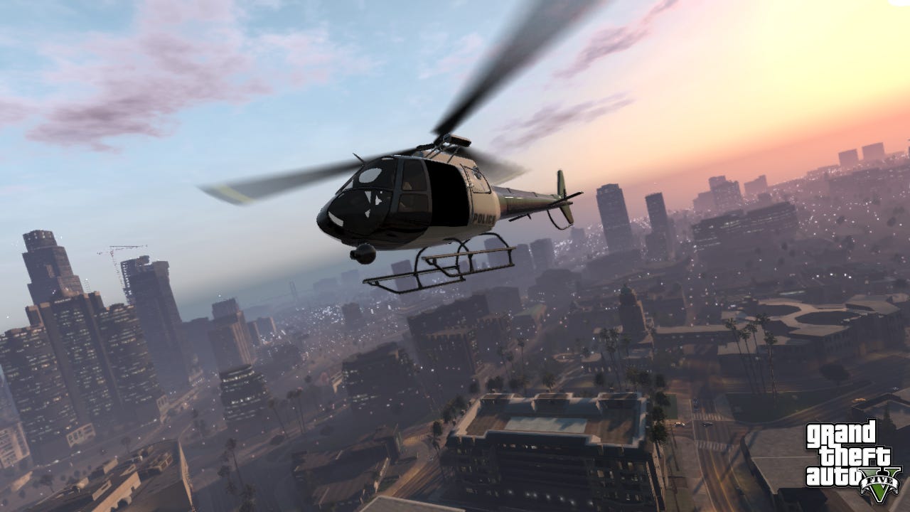
To most of us, this image conveys a single, very precise piece of information. It says that Grand Theft Auto 5 has helicopters. At the time, this wasn't even a particularly exciting tidbit. Grand Theft Auto 4 had helicopters, after all. We wanted to know about blimps, about harrier jets, about the fun stuff. But to a very particular group of GTA fans, this image was the breakthrough they'd been waiting for; the missing piece of a hugely ambitious puzzle.
"Almost all of the western part of the city came from that screen" says Thomas Rondeau, a geography graduate better known by his username on gtaforums.com, Fido_le_muet. Rondeau is a dedicated member of a band of Grand Theft Auto zealots who had set themselves a massive cartographical challenge. They were going to map the entirety of Los Santos, from airport to harbour, from golden sands to highest peaks, before the game was released.
"In the first trailer, we only saw Downtown and glimpses of Santa Monica and Venice," explains Rondeau, referring to the real-life parts of Los Angeles which Rockstar had visually ransacked to build corresponding districts in Los Santos. "But with this new [image], we saw the entire western part of the city. It made the map what it is today."
***
Unsurprisingly, cartography was one of the aspects Rondeau enjoyed most about his degree. "The basic idea I find attractive," he explains, "is starting from nothing and slowly creating something."
And the map-makers started very slowly, indeed. The first few maps were crude things, stitched together from the glimpses of the city layout they could extract from early trailers. Rockstar rarely indulges fans with overgenerous marketing, so the cartographers were working with precious little material: an aerial establishing shot here, a three-second snippet of a street corner.
They'd scrutinize the parts of screenshots the rest of us ignore: the sun-soaked, fog-shrouded backgrounds, the city streets glimpsed over an NPC's shoulders or between a helicopter's blades. It was hard work, but their passion paid off. Even Rondeau's rough, first draft was headed in the right direction: there are glimpses of accurate street layouts adrift in white space, and even the crude shape of Blaine County can be discerned. It's a map that would get more precise with each iteration as more mappers lent their time and dedication, and more geographical detail was exposed via screenshots for the fans to dissect.
So how did they do it? How did they take these context-free glimpses of the Los Santos and make an accurate blueprint - an astonishingly accurate blueprint, it would eventually turn out - of the finished city? Well, Rockstar North might be secretive, but the cartographers had one very powerful, utterly embargo-free resource at their disposal: the city of Los Angeles.
Los Santos is LA. It's not just inspired by it. It's the City of Angels refined and perverted by Rockstar North. It's not perfectly accurate, though parts of the city are near identical, and is probably best thought of as a Los Angeles highlights reel. All the tourist hotspots feature but, like a Hollywood plastic surgeon, Rockstar cuts away the fat: the residential districts, the less famous landmarks, the ugly urban sprawl. Do that, then slightly scramble the layouts of what remains before filtering every street, storefront, and billboard through the studio's distinctive brand of caricature, and Los Santos begins to emerge.
The real-life LA gave the map-makers a sense of where Los Santos' major geographical features should be, how its districts should connect. It was infinitely more useful than Grand Theft Auto: San Andreas' take on the city, which bears about as much similarity to its current gen incarnation as GTA 3's Liberty City. But, even though the fans now had a rough idea of what their finished map should look like: they still had to take each screenshot and figure out what part of the city it depicted. Looks weren't enough to go on, here. They needed something concrete - some indisputable points of connection between the real-world and the one Rockstar had created.
The landmarks. Go for a drive around Los Santos and you'll hurtle past dozens of recognisable LA features, all given a GTA-twist: the "Vinewood" sign's the most obvious one, but that's all it is, obvious. Next on the list came Downtown's distinctive skyscrapers.
"We located buildings based on where they were in real life," Rondeau explains. "We identified the obvious buildings like US Bank Tower, California Plaza, the Westin Bonaventure [and] started to locate these buildings in relation to each other. We had several maps being created at the same time at the beginning. We took ideas from each other."
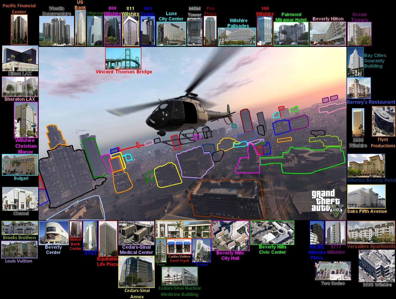
Take another look at the image that opened this article. It's a helicopter hovering over a clearly LA-inspired, but otherwise non-descript city, right? This is what it looked like to the map-makers:
"It's like a treasure hunt. You peer into screenshots, carefully combing this particular neighbourhood to find something to mark on a custom map that you have set up."
MrThingus
And that's before they started trawling through Google Streetview in order to spot more obscure buildings.
***
"It's like a treasure hunt", explains forum member MrThingus, who spotted and located locations including Powell Library and Beverley Hills' Peninsula within the game. "You peer into screenshots, carefully combing this particular neighbourhood to find something to mark on a custom map that you have set up. Finding landmarks before the game came out gave this sense of satisfaction and excitement that in a few months or weeks time I'd be able to run around a virtual Los Angeles on a level of detail very few games have ever done before."
This sense of excitement, of waiting in expectation, runs through the map-maker's efforts. These were Rockstar North's most devoted fans, so keen to experience the world they knew was being wrought for them that they tried to bring it to life in advance.
"I think the main motivation for many of us was that GTA 5 was highly anticipated," explains mapper Robert, who goes by the forum username lxr. "You couldn't play it for, well, we thought like half a year. It turned out to be much longer. How do you manage that anticipation? I think a lot of people did it because it was the only way to actually be on that map, you know?"
The map-maker's urgent need to inhabit Los Santos reflects the sheer, startling power of the worlds that Rockstar builds. Beneath that surface layer of crude, cartoonish satire, Los Santos and Liberty City somehow blend their real-life inspirations with the hyper-real, almost mythical New York and Los Angeles we know from cinema. They might not be NY or LA, but they intensely evoke them, more so than many games that have attempted more faithful renditions of either city.
It was time spent in Liberty City that inspired much of the cartography, as map-maker Koeklin, who originally started landmark spotting in GTA 4, recalls.
"I didn't know much about NYC," he explains, "I knew that Liberty City was inspired by it, but I couldn't imagine how." One day, however Koeklin found himself replaying The Snow Storm, a mid-game mission in which Niko Bellic battles through the gutted innards of a hospital in order to reclaim a stolen bag of cocaine, and found himself struck by the weirdness of the setting. What was a derelict hospital doing so close to Manhattan's - well, Algonquin's - sparkling lights?
"I found it strange that there's a vast ruined building located on Colony Island," he says, "and I wondered if there really was a place like this in NYC. I searched on Google Maps and found it easily. It's the smallpox hospital on Roosevelt Island.
"After that, I tried many other places and I was surprised to discover that they're also in New York. I couldn't see the city the same way, I felt like I was rediscovering the game. So I've naturally identified buildings in Los Santos since the first trailer for GTA 5. "
The map-maker's love for these cities is the ultimate refutation of any argument that tries reduce Grand Theft Auto to the mayhem that takes place within them. "Killing people, burning [them], crushing them under the tires of my car aren't activities that interest me in GTA," Koeklin concludes, "I have an entire city where I can walk around freely. I prefer playing tourist."
***
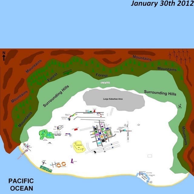
Los Santos' close relationship with LA might have been a useful tool for the urban map-makers, but what about the countryside? These cartographers had less real-world reference points to work from: Rockstar starts painting things a little less true to life the further from the city limits they're removed. Indeed, GTA 5's countryside, the shape it took, and its relation to Los Santos were all huge unknowns relatively late into the mapmaking project.
"When I joined the thread a year ago," explains Robert. "We had the city figured out, but the countryside was a big unknown. "At the time, no one expected the Alamo Sea, which is based on Salton Sea, to be north of Vinewood. We were like, 'Why would they do it? The real thing is in the South-West, it can't be!'"
Before they figured that out, however, the cartographers ran through countless possibilities. Was the map an island? A series of islands? Was Los Santos surrounded by infinitely generating desert, or invisible walls? And just how large would the rural areas, whatever shape they took, turn out to be?
"There was no idea in terms of size." Robert explains. "It was extremely hard to determine what you see [in a screenshot]: how big is that? How many kilometres could it be? Does it end there?"
And then the map-makers realised that Rockstar had given them all the clues they'd need.
Relatively early on in the marketing campaign, Rockstar released the below screenshot, which, thanks to the prominent Vinewood sign, can be easily located. More importantly, however, the screen offered a tantalising glimpse of the rural sprawl beyond the city. "This was the first screenshot we had that connected the city to something that lies beyond it," Robert recalls.
"I couldn't see the city the same way, I felt like I was rediscovering the game."
Koeklin
On its own, however, the shot was useless. Perspective and distances were near-impossible to judge, and there was no way of telling how the gloomy countryside in the background related to anything else that been shown. Those of us who've since played the game might realise that the Alamo Sea can be seen stretched out in the distance, but at the time the contents of that foggy backdrop were a matter of fierce debate. The image was analysed and obsessed over, and then set aside.
Until that is, Robert took a closer look at this image, released in the same batch of screens....
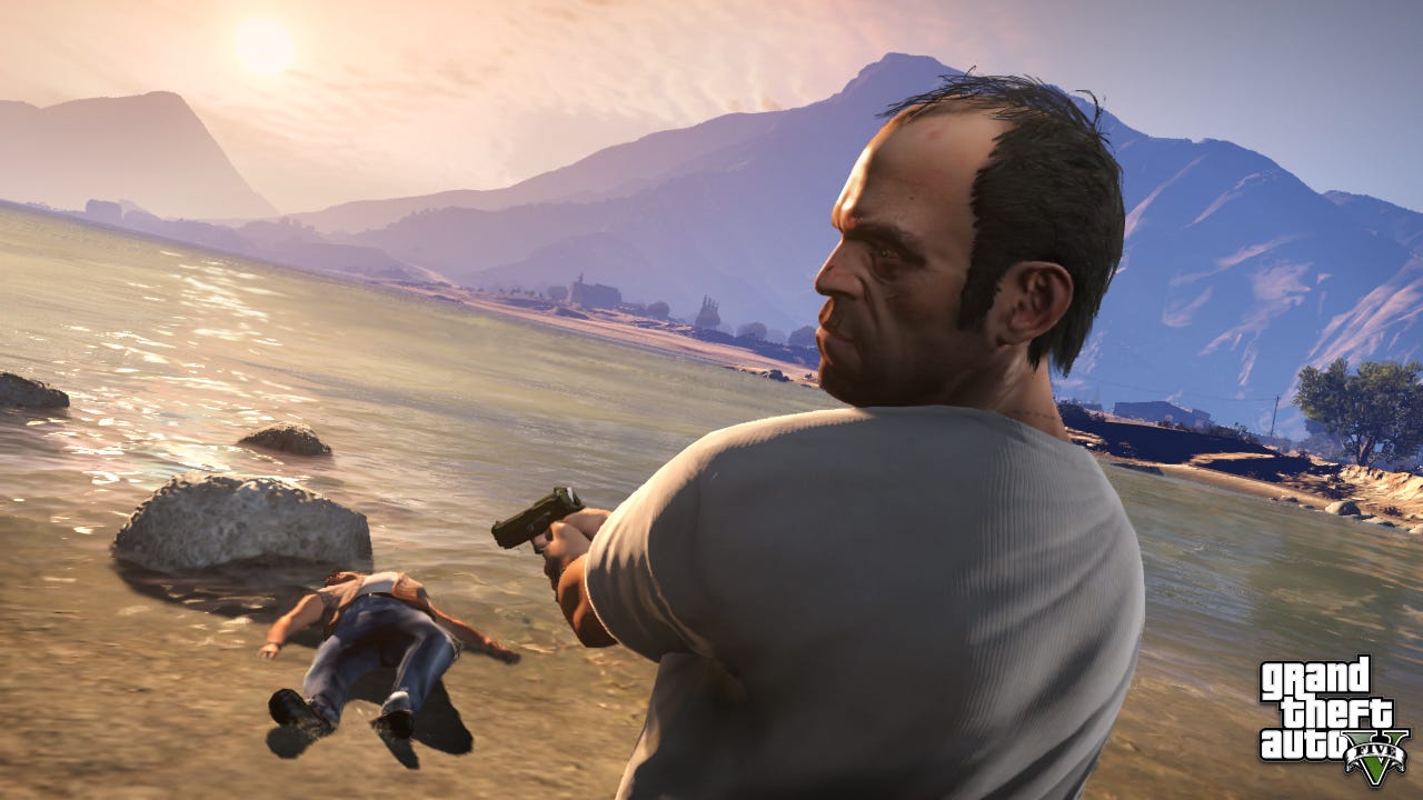
...and things started to make sense.
"If you take a look at the helicopter screenshot you can see the fog in the background," Robert explains. "What I saw after looking at this for a very long time was that, if you look at the mountain range in the very background, with three or four ridges, and then you go the Trevor screenshot, there's also a mountain in the background. And I found four or five distinct points in those ledges that were a perfect match.
"It's hard to see, because the perspective is so different. But once you see that the two images actually share very unique features, you realise that what you see in the Vinewood helicopter shot was the Alamo Sea."
This was the painstaking means by which the rural map was formed. Mappers would scour screenshots for distinctive geographical features, and then try to spot those same features in other screens, slowly building their sense of San Andreas' layout by daisy-chaining the screenshots together. It's not as easy as it sounds.
"I actually learned a lot about perspective in this year of mapping Los Santos," says Robert, laughing. "Perspective is a bitch. That map is just dramatically large, and the closer you are the ground, the larger it is. So all these screenshots have very different optics. Sometimes things seem very distant, and then in other shots that have a different focal length, they seem very close to each other.
"You learn about perspective," he continues, "about how you construct something. You learn about photogrammetry, which is basically the science of getting a photo of something and working out the three-dimensional properties of it. How do you determine what's a straight line? People - myself included - always get it wrong."
It didn't help that Rockstar occasionally cheated with their screenshots, and I'm not just talking about the odd bit of tweaked contrast:
"You can't go by the sun!" Robert laughs.
"A lot of our analysis was based on the orientation of the sun," explains Rondeau. "But we discovered that the sun wasn't always positioned as it should be. In some screens, the sun was plain north."
When Rockstar wasn't playing god in order to get the lighting just right on its screens, the studio still had the infuriating habit of constantly refining their creation, forcing the map-makers to adjust their maps in turn. And, of course, the cartographer's speculative designs constantly ran up against the many ways that San Andreas' natural geography doesn't obey the rules of real world.
"There was a case where two buildings, I think, moved over time," says Robert. "We realised. Not so much changed on the map. But you always had to be careful to not make assumptions. The Alamo sea doesn't have an inflow. We were expecting one - but it turns out it just doesn't have one. There's a reservoir up there, so it must have to have mountains around it to be a proper reservoir, right? No. You have to go by logic, but sometimes it's game logic," he explains.
"The first thing I did in the game was just get a car and drive all around the map, very slowly."
Robert
***
Still, the map-makers nailed it, as Rondeau's gif that shows the evolution of the mapping effort over time undoubtedly shows.
They were so close, in fact, that when the official map finally leaked earlier this year many players distrusted the revelation: it was suspiciously close to a fan-made map they'd seen weeks before.
"It was no surprise, we were certain we were close," says Robert, with a well-earned lack of modesty. "It was clear that we had it. Because there was a trailer, showing a heist, that actually showed parts of the map. Before anything got leaked."
***
The map-makers aren't finished. Even now they're scouring the world (and Google Streetview) to find every last architectural feature and trace it to its source. Unsurprisingly, the mapmaking project has irrevocably altered the cartographers relationship with the game, since they probably know their way around San Andreas' intricacies as well as its creators.
Robert pauses when I ask what it was like to finally step foot in Los Santos, and the countryside beyond. And then he explains.
"F***... it's... really kind of bizarre to be actually able to... because, you know, there were so many spots on the map where I thought like, 'oh, if I could just move the camera ten degrees in that screenshot'...and to suddenly be able to just go there...is nice. It's really nice. Being able to drive around on that map is fantastic. It's spectacular...The first thing I did in the game was just get a car and drive all around the map, very slowly," Robert explains.
He wanted to see how everything fitted together, the way knew it should, the way he and all the other mapmakers discovered it should. But also, he had a particular destination in mind.
"I knew of a train bridge," Robert explains, quietly. "There was no image of it, we'd just seen both ends, where the highway and the train tracks were on different sides of each other. It was clear there must be a bridge... it was really fun to see what it looked like. No one knew what it looked like. But I knew it was there."
For most of us, stepping out onto the sun-kissed streets of Los Santos last week was the beginning of an adventure: the start of endless discovery. But for the map-makers? It was the end of a long journey home.
The effort to map Los Santos was a massive collaborative effort involving more individuals than I could talk to here. Thanks to GifBrah, millionsofdeadcops, SonofUgly, J24D Smaaske, UrinalCake123. jackass2009, VickeX, sabbathfan, kendoyanar, GTAlove, JOSEPH X, BoolCaX, [enforcA], darkjounin, Vegetarian Piranha, boxmonster, Death2Drugs, jbte, Choco Taco, GTADKNUT, lxr, OUPS, GTAKiwi, zombie elvis, Angeleno, vLx, omawnakw and Wayne Kerr and many others for a great story. Good luck with GTA 6.